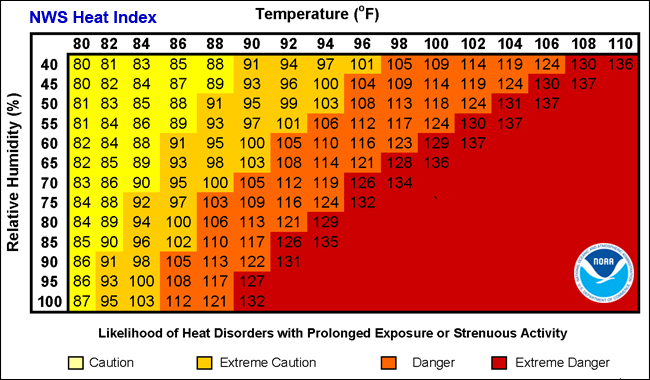
JACKSONVILLE, Fla. – The feels-like temperature could reach 112° in Jacksonville on Friday afternoon, which is dangerous for those susceptible to heat.
The record high for Friday is 97° and we will likely touch 97°. The National Weather Service has issued Heat Advisory for Putnam, inland St. Johns and Flagler counties from noon to 6 p.m.
Recommended Videos
And Friday will be the driest day this week, with only an isolated chance for an afternoon shower and likely offering no quick cool down after sunset.
This advisory is issued when the maximum heat index temperature is expected to be 100° or higher for at least two days and night time air temperatures will not drop below 75°.
The Weather Authority’s current conditions/forecast | Alerts/Watches/Warnings
Precautions to take if you have to be outside during a heat advisory:
- Avoid strenuous activities
- Wear light clothing
- Drink plenty of fluids
- Find air conditioning
- Watch for heat cramps, heat exhaustion and heat stroke
- Never leave people or pets in a closed car
- Check on family members and neighbors
Saturday will be the best day of the long weekend, weather-wise. We wake up at 76° and warm up into the sticky mid to upper 90s under mostly sunny skies. We will only see a few isolated afternoon storms popping up, most of us will stay dry.
Sunday kicks off a cloudier, wetter and not-as-hot weather pattern. we expect a few rounds of showers and thunderstorms, keeping up in the upper 80s for daytime highs. The wetter and not-as-hot weather pattern sticks around through Labor Day, with 70% chances for showers and thunderstorms with daytime highs around 88°.