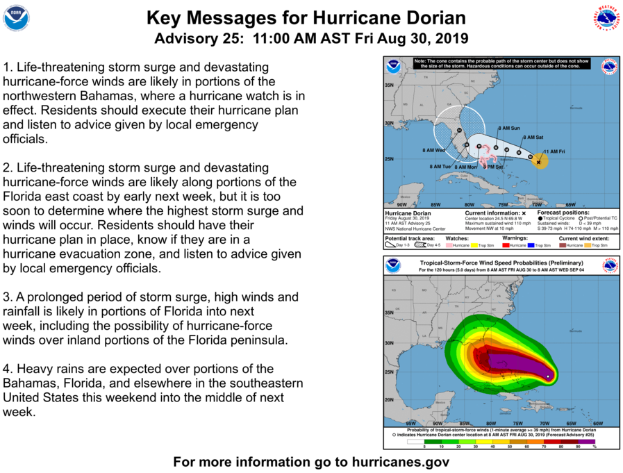
JACKSONVILLE, Fla. – The sustained winds of Hurricane Dorian remained at 110 mph at 11 a.m. Friday, keeping it a Category 2 storm as it moves over open ocean, appearing to head for the East Coast of Florida.
READ NEW STORY AS DORIAN BECOMES MAJOR HURRICANE
Recommended Videos
The storm is expected to become a major hurricane sometime Friday, and it will remain a dangerous hurricane through the weekend.
What's new this morning:
- Landfall in Southeast Florida now projected for overnight Monday or early Tuesday morning.
- Track is slowing down, meaning its impacts in Jacksonville would not start until Monday night/Tuesday and last through mid-week. Peak tropical storm wind potential late Wednesday.
- Still too early for specific north Florida surge or evacuation impacts due to uncertainty on location of north turn and its timing, but on this track, the hurricane would be more of a flooding event than a wind event in the greater Jacksonville area.
- As of 11 a.m. Friday, Dorian was moving northwest near 10 mph. A slower west-
northwestward to westward motion should begin Friday night and continue into early next week. On this track, the core of Dorian should move over the Atlantic well north of the southeastern and central Bahamas today and tomorrow, be near or over the northwestern Bahamas on Sunday, and be near the Florida peninsula late Monday.
A hurricane watch was issued for the Northwestern Bahamas
The timing of landfall was pushed to Tuesday morning, although still in the southern half of the state. The entire peninsula of Florida is within the forecast cone.
Because the track landfall calls for the storm to turn north and forward motion slow down, this could bring flooding rains into the greater Jacksonville area through much of next week.
Potential impacts for greater Northeastern Florida and Southeastern Georgia:
- Coast Flood Advisory through the weekend for potential minor flooding during high tides.
- Increasing shower chances Monday and into next week.
- Dorian may threaten the region next week.
- Local tides will already be astronomically elevated through the weekend due to the New Moon.
- Excessive rainfall potential exists if Dorian passes over or west/south of the area, putting the area on the "wet" side of the storm.
RESOURCE: Know your flood/evacuation zone
Gov. Brian Kemp declared a state of emergency for coastal counties, including Brantley, Bryan, Camden, Charlton, Chatham, Effingham, Glynn, Liberty, Long, McIntosh, Pierce and Wayne.
The state of emergency Kemp signed said, "Due to downed trees, power lines, and debris, Georgia's network of roads may be rendered impassable in the affected counties, isolating residences and persons from access to essential public services."
The state of emergency will help state agencies to assist with prep, response and recovery.