BREAKING NEWS
Arctic birders combat impact of climate change and avian flu on delicate ecosystem
Read full article: Arctic birders combat impact of climate change and avian flu on delicate ecosystemIn one of the top Arctic birding destinations in the world, environmental and health challenges are threatening some of the seabirds that are part of Norway’s unique coastal ecosystem.
To learn about climate quality, scientists turn to drones
Read full article: To learn about climate quality, scientists turn to dronesThree ocean drones were launched from Rhode Island to travel along the Gulf Stream, collecting data in tough winter conditions that would be challenging for traditional ships with crews.
:strip_exif(true):strip_icc(true):no_upscale(true):quality(65)/cloudfront-us-east-1.images.arcpublishing.com/gmg/HNWSLWNHBNCVDKXPOYTL6DWWT4.png)
:strip_exif(true):strip_icc(true):no_upscale(true):quality(65):fill(FFF)/cloudfront-us-east-1.images.arcpublishing.com/gmg/ZQKP7G5KLVFJJJVC2W66YEXYSY.png)
:strip_exif(true):strip_icc(true):no_upscale(true):quality(65):fill(FFF)/cloudfront-us-east-1.images.arcpublishing.com/gmg/XF3ER2W2DJDN3F2OMN6RSGVINE.png)
:strip_exif(true):strip_icc(true):no_upscale(true):quality(65)/cloudfront-us-east-1.images.arcpublishing.com/gmg/7KRHPBBJFRABTNAIRPVLAADJOU.png)
How will Isaias impact Jacksonville area?
Read full article: How will Isaias impact Jacksonville area?Plus, Tropical Storm Isaias taking a track well to the east of Jacksonville, our impacts will remain minimal. Yet, Isaias will impact our Southern coastal counties and along the St. Johns River in Clay and Putnam counties the most. The nearest approach will be about 100 miles off area beaches and will be there around 8-10 am. If there is to be some impact, it will be between 6 a.m. until noon. Maximum beach winds from Jacksonville beach northward will remain just barely at tropical storm force -- 40 mph.
Tropical Storm Dorian could impact our Labor Day
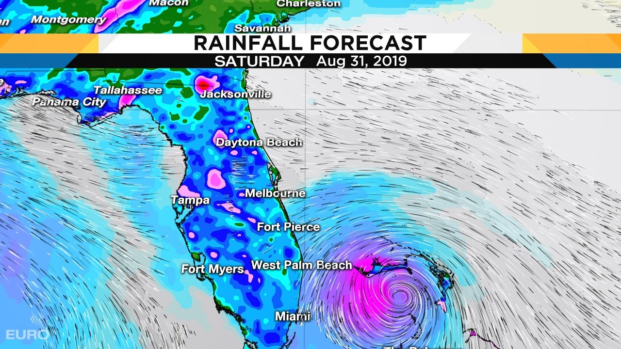
Read full article: Tropical Storm Dorian could impact our Labor DayEURO increases the strength of Dorian near the Gulf Stream after leaving the Bahamas Saturday,JACKSONVILLE, Fla - Should Tropical Storm Dorian last through the week, it could impact our Labor Day. During the next couple of days it will be interesting to see if Dorian can power up to hurricane strength as predicted by the National Hurricane Center. The NHC no longer brings Dorian to hurricane strenght before landfall in the Dominican Republic, but does keep it at storm strength impacting Florida this weekend. EURO increases the strength of Dorian near the Gulf Stream after leaving the Bahamas Saturday,Heavy rain in red soaks the state as Dorian's center moves across Florida Labor Day. Until Thursday, any potential impacts from Dorian in Florida are highly uncertain, given the potential for the system to interact with Hispaniola.
Tropical Storm Dorian could impact our Labor Day
Read full article: Tropical Storm Dorian could impact our Labor DayEURO increases the strength of Dorian near the Gulf Stream after leaving the Bahamas Saturday,JACKSONVILLE, Fla - Should Tropical Storm Dorian lasts through the week it could impact our Labor Day. During the next couple of days it will be interesting to see if Dorian can power up to hurricane strength as predicted by the National Hurricane Center. NHC boosted the extended track from tropical depression to tropical storm strength but confidence is low whether Dorian will last to the weekend,Models have less skill predicting intensity in compact systems like Dorian when storm force winds extend out just 45 miles. If it restrengthens near the very warm waters in the Bahamas the steering flow would likely bring rain to Florida starting Saturday through Labor Day. EURO increases the strength of Dorian near the Gulf Stream after leaving the Bahamas Saturday,Heavy rain in red soaks the state as Dorian's center moves across Florida Labor Day.

Steamy, hot and a bit parched
Read full article: Steamy, hot and a bit parchedJACKSONVILLE, Fla - Today will be steamy, hot and a bit parched. We will be dry today with low rain chances at 20% primarily targeting southern Georgia and north central inland Florida. Sea Breeze sweeps clouds inland through the afternoon with mostly sunny skies. A tropical disturbance in the Straits of Florida will move north up the Gulf Stream with no noticeable impacts to us other than keeping rain chances suppressed today and Saturday at 20%. It could become a Tropical Storm offshore Cape Hatteras Monday at which point moisture increases over Jacksonville in the systems wake boosting rain chances to 60-70% to start next week.
Searching for missing boaters weather forecast
Read full article: Searching for missing boaters weather forecastIt was located near the Canaveral Shoals which is a shallow area inside of the Gulf Stream. If this was from the missing boaters the location would mean the distressed vessel could have drifted less than if it disappeared in the faster flowing Gulf Stream. Knowing exactly where to look is made difficult because the Gulf Stream moves at various speeds. The two firefighters who went fishing on Friday off Central Florida's East Coast could be anywhere in a 24,000 square-mile area of the Atlantic Ocean. The Gulf Stream is a challenging place to find stranded boaters, and, based on current models the two firefighters could be adrift anywhere from Jacksonville to Cape Hatteras, North Carolina.