BREAKING NEWS
John Gaughan: Jacksonville should go through basic hurricane preps for Ian this weekend
Read full article: John Gaughan: Jacksonville should go through basic hurricane preps for Ian this weekendWith the current cone forecast being what it is, please take a moment to do a few essential steps, just in case it does follow the current NHC forecast.
Tropical drought ends this week as Danielle and possibly Earl form by Saturday
Read full article: Tropical drought ends this week as Danielle and possibly Earl form by SaturdayNews4JAX Insiders know, from the Weather Authority’s newsletters since July, that it would not be until late August before we would see our next named storm.
Party crasher to this year’s official start of hurricane season?
Read full article: Party crasher to this year’s official start of hurricane season?Once upon a time, not too many years ago, I could look into the predicted world weather patterns and see, well in advance, when there could be conducive properties for tropical storm development. I could identify these conditions and then sit on the thought, for maybe a week, or longer, to see whether or not if these predicted conditions actually would come together.
:strip_exif(true):strip_icc(true):no_upscale(true):quality(65)/cloudfront-us-east-1.images.arcpublishing.com/gmg/FX6LIKQARVGCDFOVVSVJ2CJ7C4.png)
Rain, rain, go away
Read full article: Rain, rain, go awayForecast models are all over the place when dealing with the current rainy weather pattern. The GFS is now suggesting another 2-4″ of rain is possible just through Friday evening. The EURO is not as wet with an anticipated 1-2″ of rain through Friday evening and the NAM/RPM/IBM/Baron 3KM are all in the middle showing 1-3″ of rain possible.
:strip_exif(true):strip_icc(true):no_upscale(true):quality(65):fill(FFF)/cloudfront-us-east-1.images.arcpublishing.com/gmg/WKETNQYV4NA3LCNVUHE6INYWH4.png)
A big fork in Tropical Storm Elsa’s path
Read full article: A big fork in Tropical Storm Elsa’s pathAt 8 a.m. Thursday, newly named Tropical Storm Elsa had 40 mph sustained winds and was moving rapidly west, but still 780 miles east-southeast of the Windward Islands, according to the National Hurricane Center.
:strip_exif(true):strip_icc(true):no_upscale(true):quality(65)/cloudfront-us-east-1.images.arcpublishing.com/gmg/5I4S6ODK6BFUFMYNVT7KR7QJJA.png)
Big time challenging forecast this weekend as Friday starts off with more fog
Read full article: Big time challenging forecast this weekend as Friday starts off with more fogJACKSONVILLE, Fla. – After decades of forecasting, I have always been leery over the “sure thing” forecast. As we head into the weekend, the forecast models sure seem to be telling everyone who is willing to listen that heavy rains are a “sure thing” for this weekend. Yet, this is where the forecast models really unload, forecasting anywhere between 2-5″ of rain over a 5 day period from Friday afternoon through Tuesday evening. Once again, driving through the sunrise fog, drive much more cautiously than normal as the fog appears to be variably thick. With afternoon highs that warm, there will be a few pop-up afternoon and evening showers, maybe even a rumble of thunder.
:strip_exif(true):strip_icc(true):no_upscale(true):quality(65)/cloudfront-us-east-1.images.arcpublishing.com/gmg/HTWZNQSNFBFZ5GUAGF2CN5MMCM.jpg)
The best new hurricane model you may not know about
Read full article: The best new hurricane model you may not know aboutHAFS was the most accurate model to predict Cat 5 Hurricane Dorian as it hit the Bahamas Sept 2019. This model is still in development but took top place for track accuracy during the 2019 hurricane season, according to hurricane scientists at NOAA’s Atlantic Oceanographic and Meteorological Laboratory (AOML). The regional and global HAFS had lower track errors during the 2019 hurricane season compared to other NOAA models. In cases like Hurricane Dorian, the regional HAFS track outperformed the GFS, HWRF and HMON. AdHAFS never predicted hurricane Dorian to hit Florida while the GFS (A), HWRF (B), and HMON (C) all did.
:strip_exif(true):strip_icc(true):no_upscale(true):quality(65)/cloudfront-us-east-1.images.arcpublishing.com/gmg/TRLDLSIOHRFRLOJN2VSOFTE3CU.png)
It’s OK to dream as the Euro and now the GFS snowfall forecasts want to go wild
Read full article: It’s OK to dream as the Euro and now the GFS snowfall forecasts want to go wildDon't go Lloyd Christmas on me (Jim Carey's character in Dumb and Dumber). JACKSONVILLE, Fla. – Update: Keeping the dream alive, maybe up to a 2-5% chance from Central Georgia northward for a major snow event. The GFS is now also “hinting” there could be a major snow event deep into the South. About two or three times each winter, the global forecast models (Euro and GFS) fly off the rails. This year’s crazy story is coming from the Euro Global Forecast Model.
:strip_exif(true):strip_icc(true):no_upscale(true):quality(65)/cloudfront-us-east-1.images.arcpublishing.com/gmg/6A33GV5GZZDR5HXFVDC3XBFUNA.jpg)
Eta’s alarming path toward north Florida is far from certain
Read full article: Eta’s alarming path toward north Florida is far from certainThe National Hurricane Center’s NHC forecast track on Monday morning had a cone of uncertainty nearly 400 miles wide by the end of the week, extending from Pensacola east to Cape Canaveral. Yes, that cone includes Jacksonville, but the confidence in the forecast models with this storm is especially low. It leaves the Keys on a slow path Monday morning out west past the Dry Tortugas. After that Eta will meander in the Gulf west of Florida before it decides which route to take next. Parallel track lines lead to high confidence in forecast path next 24-48 hours.
:strip_exif(true):strip_icc(true):no_upscale(true):quality(65)/cloudfront-us-east-1.images.arcpublishing.com/gmg/3WKUAG3EI5HZPDNVBHOQTIUCKI.PNG)
System may develop into Epsilon
Read full article: System may develop into EpsilonJACKSONVILLE, Fla. – Long term forecast model (the GFS) has consistently shown a system developing South of Cuba around October 22nd. What has not been consistent is where this system ends up- in the Gulf, tracking over Florida, or curving northward into the Atlantic. It’s too soon to tell where the potential system may end up, but it does look like we will end up with a system named Epsilon, the next name in the Greek Alphabet. Wednesday’s model runs brought the path back towards the coastline of Florida, but not too close, meaning no serious impact. It’s likely that the forecast models won’t have a firm idea of where the potential system will end up until Friday or Saturday.
:strip_exif(true):strip_icc(true):no_upscale(true):quality(65)/cloudfront-us-east-1.images.arcpublishing.com/gmg/5LNW44XI6BEKVMJR652MTLQOZ4.png)
Tracking The Tropics: heres the next system to watch
Read full article: Tracking The Tropics: heres the next system to watchJACKSONVILLE, Fla. A broad area of low pressure appears to be developing over the central Atlantic Ocean several hundred miles east-southeast of Bermuda. Additional development of this system is possible, and a subtropical depression could form tonight or on Saturday as it moves generally northward. The NHC places a 50% chance on the system to form within the next 48 hours. Regardless of development, this system is expected to remain largely at sea and not expected to move towards us. In addition to this area we are monitoring, long term forecast models are hinting that there will be a tropical system developing in the Gulf at the end of the first week of June.

Hurricane forecasting EURO vs GFS
Read full article: Hurricane forecasting EURO vs GFSYou will hear me often cite the two most well-known global forecast models the GFS and Euro. They both represent some of the most sophisticated and complex forecast models that mankind has ever created. There are many other global forecast models at the National Hurricane Center's disposal. Anyhow, back to our current situation, as seen with the pics below, the National Hurricane Center is basically running faster and splitting the difference between the GFS and Euro. See how the Euro, GFS and NHC start at the same location, but quickly spread apart.

Tropical system to become depression or named storm today
Read full article: Tropical system to become depression or named storm todayWith the current forecast track for Potential Tropical Cyclone 9, our local forecast actually improves for the weekend. A Tropical Storm Warning remained in effect for the Northwestern Bahamas, excluding Andros Island. A Tropical Storm Watch was issued Friday for part of Florida's East Coast, from Jupiter Inlet to the Flagler-Volusia County line. Tropical storm conditions are possible in the watch area on the Florida peninsula by Saturday. This graphic shows what the Global Forecast System model predicts for this system over the weekend.

Here we go again: We'll soon be talking about Humberto
Read full article: Here we go again: We'll soon be talking about HumbertoAfter what the Bahamas just endured with Hurricane Dorian, all eyes are keeping watch on what the National Hurricane Center is saying about a new area of disturbance that could become "Humberto." Based on what they find, this system may be declared a Tropical Depression or a Tropical Storm. This forecast model develops the system into a Hurricane and keeps it off of the Florida coast as it curves off to the north and then northeast. If this were to occur we would see even less rain and wind than what we saw with Dorian. This disturbance will bring heavy rainfall and gusty winds across portions of the Bahamas through Friday, especially in portions of the northwestern Bahamas affected by Hurricane Dorian.
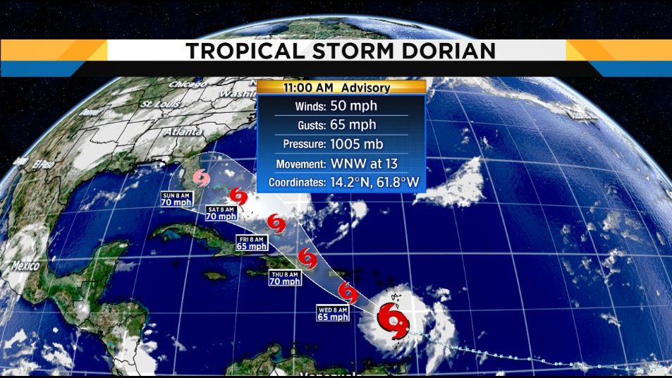
Tropical Storm Dorian moves across St. Lucia into Caribbean Sea
Read full article: Tropical Storm Dorian moves across St. Lucia into Caribbean SeaPuerto Rico and the Dominican Republic are under a hurricane watch and tropical storm warnings for Martinique and St. Vincent and the Grenadines as Tropical Storm Dorian approaches. This means a continued path just south of Puerto Rico and then interaction with possible landfall on the Dominican Republic Wednesday night. The latest adjustment to Tropical Storm Dorian's forecast keeps it stronger longer, but keeps below hurricane strength as it passes through the Caribbean. She said public schools would close Tuesday afternoon and that at least one cruise ship canceled its trip to Puerto Rico. It was expected to become a tropical storm by Tuesday night and continue blowing off the U.S. East Coast this week on a path to Canada's North Atlantic provinces.

Tropical storm could end Jacksonville's wet spell
Read full article: Tropical storm could end Jacksonville's wet spellTropical Storm Barry may develop late in the week and track westward away from Jacksonville. JACKSONVILLE, Fla. - It may take a tropical storm to finally bring an end to Jacksonvilles daily downpours. It's all because of a classic June/July northern Gulf tropical development set-up. We know tropical systems must spin in a circulation in order to concentrate the system's energy. If this plays out as expected, Tropical Storm Barry could impact the northern Gulf states by the end of the week.