WEATHER ALERT
Capris to culottes: Crop pants done right
Read full article: Capris to culottes: Crop pants done rightStephanie Mack joined RCL to talk about capris, crop pants, cullottes, and Bermuda shorts. Understanding the differences between these four styles is key to nailing the trend. Capris hit mid-calf with a tailored, fitted silhouette perfect for elevated everyday looks. Cropped pants end just above the ankle and offer the most versatility—they’re your foolproof starting point. Culottes bring wide-leg drama that falls between the knee and ankle, requiring heels to balance their volume.
Imelda weakens after downing trees and power lines in Bermuda as a hurricane
Read full article: Imelda weakens after downing trees and power lines in Bermuda as a hurricaneCrews across Bermuda have started clearing streets after Hurricane Imelda swiped past the tiny British territory as a Category 2 storm, downing trees, power lines and transformers.
Hurricane Imelda descends on Bermuda with damaging wind and waves
Read full article: Hurricane Imelda descends on Bermuda with damaging wind and wavesHurricane Imelda is nearly on top of Bermuda as a Category 2 storm that forecasters have warned is expected to bring potentially destructive weather to the British territory.
Imelda strengthens into Cat 1 hurricane; Dangerous surf, strong winds, high rip current risk at Jacksonville beaches
Read full article: Imelda strengthens into Cat 1 hurricane; Dangerous surf, strong winds, high rip current risk at Jacksonville beachesAlthough the storm will remain far from land, its effects will be felt strongly along the coast, bringing dangerous surf, strong winds, and a high risk of rip currents.
Bermuda lashed by distant hurricane and prepares for the stronger Imelda
Read full article: Bermuda lashed by distant hurricane and prepares for the stronger ImeldaThe outer bands of Hurricane Humberto are lashing Bermuda ahead of a more direct pass from the stronger Hurricane Imelda on the tiny British territory.
LIVE at 10 am: Here’s the latest on Hurricane Gabrielle and the 2 other disturbances in the Atlantic
Read full article: LIVE at 10 am: Here’s the latest on Hurricane Gabrielle and the 2 other disturbances in the AtlanticHurricane Gabrielle has intensified rapidly, now reaching Category 4 strength with sustained winds near 140 mph (220 km/h).
Gabrielle becomes at Category 4 hurricane and forecasters advise Azores to take notice
Read full article: Gabrielle becomes at Category 4 hurricane and forecasters advise Azores to take noticeThe National Hurricane Center advised people in the Azores to monitor the progress of Hurricane Gabrielle which is now a Category 4 hurricane in the central Atlantic Ocean.
Tropical Storm Gabrielle increases in speed, expected to become a hurricane Sunday
Read full article: Tropical Storm Gabrielle increases in speed, expected to become a hurricane SundayThis slow-moving storm system is expected to continue along this path until Sunday night when a turn to the north is forecast on Monday.
LIVE at 10am: Hurricane Erin and dangerous rip currents threaten East Coast beaches
Read full article: LIVE at 10am: Hurricane Erin and dangerous rip currents threaten East Coast beachesHurricane Erin brings life-threatening rip currents and high surf along the East Coast, with evacuations in the Outer Banks. News4JAX's meteorologist tracks Erin, rising water rescues, and two additional systems brewing in the Atlantic.
Heavy rains expected in Puerto Rico and Virgin Islands as Hurricane Erin nears
Read full article: Heavy rains expected in Puerto Rico and Virgin Islands as Hurricane Erin nearsHurricane Erin has strengthened into a Category 2 storm as it approaches Puerto Rico and the Virgin Islands, bringing heavy rains that could cause flooding and landslides.
Keeping a sharp eye on 2 disturbances as Tropical Storm Dexter heads out to sea
Read full article: Keeping a sharp eye on 2 disturbances as Tropical Storm Dexter heads out to seaTropical Storm Dexter formed on Sunday, but it’s expected to move away from the U.S. coast and stay north of Bermuda, so there is no threat from that storm.
Short-lived tropical depression could form out in Atlantic east of Bermuda
Read full article: Short-lived tropical depression could form out in Atlantic east of BermudaA disorganized area of showers and thunderstorms and an area of low pressure about 600 miles east of Bermuda has a high chance of developing into a short-lived tropical depression on Monday. But the window is small.
Hurricane Kirk strengthens into a Category 4 storm in the Atlantic
Read full article: Hurricane Kirk strengthens into a Category 4 storm in the AtlanticForecasters say Hurricane Kirk has strengthened into a Category 4 storm in the Atlantic Ocean and waves caused by it could cause life-threatening surf and rip current conditions this weekend.
Ernesto regains hurricane strength, sends powerful swells, dangerous rip currents to US East Coast
Read full article: Ernesto regains hurricane strength, sends powerful swells, dangerous rip currents to US East CoastErnesto has regained hurricane status as the storm churns away from Bermuda and heads farther out into the northeastern Atlantic Ocean.
Hurricane Ernesto weakens into tropical storm as it moves away from Bermuda over open waters
Read full article: Hurricane Ernesto weakens into tropical storm as it moves away from Bermuda over open watersHurricane Ernesto has weakened into a tropical storm as it moves away from Bermuda over open waters of the Atlantic after crossing over the tiny British territory early in the day with heavy rains and strong winds.
Hurricane Ernesto lashes Bermuda as wealthy British territory closes down
Read full article: Hurricane Ernesto lashes Bermuda as wealthy British territory closes downHurricane Ernesto has started to pound Bermuda with heavy winds and rain after officials on the tiny British territory in the middle of the Atlantic Ocean opened shelters and closed government offices.
Ernesto grows into Cat 2 hurricane as it aims for Bermuda, leaving many in Puerto Rico without power
Read full article: Ernesto grows into Cat 2 hurricane as it aims for Bermuda, leaving many in Puerto Rico without powerHurricane Ernesto has strengthened into a Category 2 storm as it barrels toward Bermuda after leaving hundreds of thousands of people in Puerto Rico without power or water.
Hurricane Ernesto’s impact on local surf breaks and the unusual conditions for the Hammerhead Ocean Marathon
Read full article: Hurricane Ernesto’s impact on local surf breaks and the unusual conditions for the Hammerhead Ocean MarathonA forecast for surfers and swimmers made by a local meteorologist...not someone from California.
Hurricane Ernesto drops torrential rain on Puerto Rico as it strengthens heading toward Bermuda
Read full article: Hurricane Ernesto drops torrential rain on Puerto Rico as it strengthens heading toward BermudaHurricane Ernesto has dropped torrential rain on Puerto Rico and knocked out power for nearly half of all customers in the U.S. territory.
Tropical Storm Philippe chugs toward Bermuda on a path to Atlantic Canada and New England
Read full article: Tropical Storm Philippe chugs toward Bermuda on a path to Atlantic Canada and New EnglandTropical Storm Philippe is aiming for Bermuda on a path that would eventually take it to Atlantic Canada and eastern New England.
Tropical Storm Philippe soaks northeast Caribbean on a path toward Bermuda, New England and Canada
Read full article: Tropical Storm Philippe soaks northeast Caribbean on a path toward Bermuda, New England and CanadaTropical Storm Philippe is drenching the U.S. and British Virgin Islands as it spins away from the northeast Caribbean on a path that would take it toward Bermuda and later New England and Atlantic Canada.
Philippe Becomes Post-Tropical But Still Poses A Risk Of Flash Flooding Across New England This Weekend
Read full article: Philippe Becomes Post-Tropical But Still Poses A Risk Of Flash Flooding Across New England This WeekendAt 1100 AM AST (1500 UTC), the center of Post-Tropical Cyclone Philippe was located near latitude 30.7 North, longitude 64.6 West. The post-tropical cyclone is moving toward the north-northeast near...
Rough surf batters Bermuda as Hurricane Nigel charges through open waters
Read full article: Rough surf batters Bermuda as Hurricane Nigel charges through open watersForecasters in Bermuda are warning of dangerous swells and rip currents as Hurricane Nigel spun through open waters in the northern Atlantic.
Heavy surf is pounding Bermuda as Hurricane Lee aims for New England and Atlantic Canada
Read full article: Heavy surf is pounding Bermuda as Hurricane Lee aims for New England and Atlantic CanadaThe outer bands of Hurricane Lee are starting to lash Bermuda as big surf pounded the island, with the Category 2 storm expected to make landfall on the coast of New England or Atlantic Canada over the weekend.
Tropical Storm Warning Discontinued For Bermuda, This Is The Last Nhc Advisory
Read full article: Tropical Storm Warning Discontinued For Bermuda, This Is The Last Nhc AdvisoryAt 500 PM AST (2100 UTC), the center of Post-Tropical Cyclone Idalia was located near latitude 32.0 North, longitude 62.7 West. Idalia is moving toward the east-northeast near 7 mph (11 km/h), and...
Major Hurricane Fiona’s wind field grows as it churns toward Bermuda
Read full article: Major Hurricane Fiona’s wind field grows as it churns toward BermudaTropical Storm Fiona strengthened to a Category 1 hurricane Sunday morning as it continued to pour heavy rains over portions of the Leeward Islands, Virgin Islands and Puerto Rico, according to the National Hurricane Center.
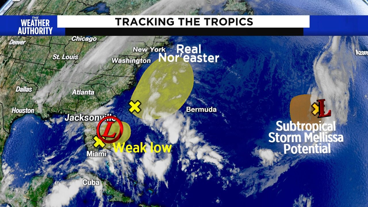
Beaches dealing with sub-tropical system and mini-nor’easter
Read full article: Beaches dealing with sub-tropical system and mini-nor’easterHurricane season is still officially beginning on June 1st, but often times we see sub-tropical (winter, cold core) systems develop over the Atlantic Ocean and then drift southward over tropical warm waters. After a few days of spinning over these warmer waters, prest-o-change-o and we end up with a hybrid system that the National Hurricane Center ultimately names, even before the official start of hurricane season.
:strip_exif(true):strip_icc(true):no_upscale(true):quality(65)/cloudfront-us-east-1.images.arcpublishing.com/gmg/5GOZRRJGSNGZTORXOTNCPY57UM.jpg)
Haiti braces for Grace, Florida for Fred as storms brew
Read full article: Haiti braces for Grace, Florida for Fred as storms brewTropical Depression Grace is drenching Haiti, dumping up to 15 inches of rain on a quake-damaged landscape as thousands of people huddle in fields and search for survivors.
:strip_exif(true):strip_icc(true):no_upscale(true):quality(65)/cloudfront-us-east-1.images.arcpublishing.com/gmg/IL422WWT4NF6RFRVZ77EES73EU.png)
:strip_exif(true):strip_icc(true):no_upscale(true):quality(65):fill(FFF)/cloudfront-us-east-1.images.arcpublishing.com/gmg/BDW6GGL4LZB3ZCPN3VNTNUAQRU.png)
:strip_exif(true):strip_icc(true):no_upscale(true):quality(65):fill(FFF)/cloudfront-us-east-1.images.arcpublishing.com/gmg/XJEVI4LXRFG7HOV6RT7FD34YVY.png)
Subtropical cyclone Ana to be declared later today?
Read full article: Subtropical cyclone Ana to be declared later today?Of the two systems the National Hurricane Center is tracking, the first one that was declared as an area of investigation Thursday morning is the one that will likely become subtropical storm Ana.
:strip_exif(true):strip_icc(true):no_upscale(true):quality(65):fill(FFF)/cloudfront-us-east-1.images.arcpublishing.com/gmg/GSF3DB2J2BFJJO46OCVN3C6I4Q.PNG)
:strip_exif(true):strip_icc(true):no_upscale(true):quality(65)/cloudfront-us-east-1.images.arcpublishing.com/gmg/35CWA32MVNGKBMLJ7V3N7LFKUQ.jpg)
Weakened Hurricane Epsilon moves north over Atlantic Ocean
Read full article: Weakened Hurricane Epsilon moves north over Atlantic OceanMIAMI – A weakened Hurricane Epsilon moved northward Friday over the Atlantic Ocean, a day after after skirting well east of Bermuda. Epsilon's top sustained winds fell Thursday to 85 mph (140 kph), dropping it from a Category 2 to a Category 1 storm, the U.S. National Hurricane Center said. But large ocean swells could cause life-threatening surf and rip current conditions along the coast of New England and Atlantic Canada during the next couple of days, the hurricane center warned. Earlier in the week, Epsilon had gained 50 mph (80 kph) in wind speed in just 24 hours to become a major hurricane on Wednesday. This year's season has had so many storms that the hurricane center has turned to the Greek alphabet after running out of official names.
:strip_exif(true):strip_icc(true):no_upscale(true):quality(65)/cloudfront-us-east-1.images.arcpublishing.com/gmg/S6GEDBUD3VFWVNNQC5UXPCEUL4.jpg)
Weakened Hurricane Epsilon skirting well east of Bermuda
Read full article: Weakened Hurricane Epsilon skirting well east of BermudaMIAMI – A weakened Hurricane Epsilon skirted well east of Bermuda on Thursday night, prompting officials to lift a tropical storm warning for the Atlantic island. The Miami-based center said Epsilon was about 190 miles (300 kilometers) east of Bermuda at 11 p.m as it moved north-northwest at 9 mph (15 kph). Forecasters said the storm would track over the Atlantic Ocean well east of the island in coming hours. Earlier in the week, Epsilon had gained 50 mph (80 kph) in wind speed in just 24 hours to become a major hurricane on Wednesday. This year's season has had so many storms that the hurricane center has turned to the Greek alphabet after running out of official names.
:strip_exif(true):strip_icc(true):no_upscale(true):quality(65)/cloudfront-us-east-1.images.arcpublishing.com/gmg/Q4IMCGEVBZH6RI7PKRYYMGCWZY.png)
Epsilon strengthens to a hurricane as it approaches Bermuda
Read full article: Epsilon strengthens to a hurricane as it approaches BermudaMIAMI – Tropical Storm Epsilon strengthened into a hurricane, the 10th of the Atlantic season. At 5 a.m. the center of Hurricane Epsilon was located near latitude 30.6 North, longitude 60.9 West. On the forecast track, the center of Epsilon is forecast to make its closest approach to, but well to the east of, Bermuda later this evening. Hurricane-force winds extend outward up to 25 miles from the center and tropical-storm-force winds extend outward up to 310 miles. TRACK THE TROPICS: Interactive mapThis year’s hurricane season has had so many storms that the Hurricane Center has turned to the Greek alphabet for storm names after running out of official names.
:strip_exif(true):strip_icc(true):no_upscale(true):quality(65)/cloudfront-us-east-1.images.arcpublishing.com/gmg/OJFDWFTDSRHHVFJYYQE466B7WU.jpg)
Epsilon Becomes A Powerful Post-Tropical Cyclone Over The North Atlantic
Read full article: Epsilon Becomes A Powerful Post-Tropical Cyclone Over The North AtlanticLocation 675 miles ENE of Cape Race Newfoundland Wind 70 mph Heading NE at 46 mph Pressure 28.59 Coordinates 38.8W, 48.6NDiscussionAt 300 AM GMT (0300 UTC), the center of Post-Tropical Cyclone Epsilon was located near latitude 48.6 North, longitude 38.8 West. The post-tropical cyclone is moving toward the northeast near 46 mph (74 km/h), and this general motion is expected to continue through Monday night. Maximum sustained winds are near 70 mph (110 km/h) with higher gusts. Little change in strength is forecast during the next day or so before the post-tropical cyclone is absorbed by a large extratropical low pressure system on Monday night or early Tuesday. Tropics Models at 9:10 Monday Morning, October 26thLand HazardsSURF: Large swells generated by Epsilon will affect Bermuda, the Bahamas, the Greater Antilles, the Leeward Islands, portions of the east coast of the United States, and Atlantic Canada through Monday.
:strip_exif(true):strip_icc(true):no_upscale(true):quality(65)/cloudfront-us-east-1.images.arcpublishing.com/gmg/ICJQPCPLIFGBDNS2QQRCO3E4AQ.png)
Two areas to watch for development in the tropics
Read full article: Two areas to watch for development in the tropicsJACKSONVILLE, Fla. – We are watching two areas in the tropics for the potential for development. One is more likely to develop and will most likely remain out over the open ocean. The other is less likely to develop until next week, but may end up being a concern. Formation chance through 5 days: medium at 60%Two areas may develop next weekNext is the system we may end up watching closely. It’s too soon to tell where this possible system may end up, but at this point it bears watching.
:strip_exif(true):strip_icc(true):no_upscale(true):quality(65)/cloudfront-us-east-1.images.arcpublishing.com/gmg/NCQ4CFMU4RF4LCJKUU5UI5NARA.jpg)
Paulette rolls toward Bermuda; Sally threatens Gulf Coast
Read full article: Paulette rolls toward Bermuda; Sally threatens Gulf CoastMIAMI – Residents of Bermuda were urged to prepare to protect life and property ahead of Hurricane Paulette, while Tropical Storm Sally threatened to intensify into a hurricane as it approached the U.S. Gulf Coast. Paulette had maximum sustained winds of 80 mph (130 kph) as the system moved along a curved course toward Bermuda, forecasters said. The biggest threats were strong winds, storm surge, up to 6 inches (15 centimeters) of rain and life-threatening surf and rip currents. A slow moving storm, Sally could produce rain totals up to 20 inches (51 centimeters) by the middle of the week, forecasters said. Tropical Depression Twenty was expected to strengthen this week and become a tropical storm by Tuesday, forecasters said.
:strip_exif(true):strip_icc(true):no_upscale(true):quality(65)/cloudfront-us-east-1.images.arcpublishing.com/gmg/H5S2AUOEHJESHFTTS5JE2U2QUQ.jpg)
Teddy Heading Toward The Northwest Coast Of Newfoundland
Read full article: Teddy Heading Toward The Northwest Coast Of NewfoundlandLocation 530 miles NNE of Halifax Nova Scotia Wind 50 mph Heading NNE at 32 mph Pressure 28.8 Coordinates 57.3W, 51.0NDiscussionAt 1100 PM AST (0300 UTC), the center of Post-Tropical Cyclone Teddy was located near latitude 51.0 North, longitude 57.3 West based on the Marble Mountain, Newfoundland, radar and surface observations along the west coast of Newfoundland. On the forecast track, the center of Teddy should move closer to the northwestern Newfoundland coast tonight and into the Labrador Sea on Thursday before merging with a larger extratropical low. By the Sea, Newfoundland (near the Cow Head Lighthouse) reported a barometric pressure of 979 mb (28.91 inches). SURF: Large swells generated by Teddy are affecting Bermuda, the Lesser Antilles, the Greater Antilles, the Bahamas, the east coast of the United States, and Atlantic Canada. WIND: Gusty winds are possible along the western coast of Newfoundland tonight.
:strip_exif(true):strip_icc(true):no_upscale(true):quality(65)/cloudfront-us-east-1.images.arcpublishing.com/gmg/574WVFRFBZCOFMLXKBW7TTJWFI.jpg)
New Orleans under hurricane watch from Tropical Storm Sally
Read full article: New Orleans under hurricane watch from Tropical Storm SallyMIAMI – Tropical Storm Sally formed Saturday off south Florida, becoming the earliest 18th-named storm on record in an Atlantic hurricane season as it enters the Gulf of Mexico amid signs of strengthening further. In the National Hurricane Center's 5 p.m. forecast, meteorologists said a hurricane watch is in effect for metropolitan New Orleans. A tropical storm watch has been extended westward from the Okaloosa/Walton County Line to the Alabama/Florida Border. Meanwhile, Tropical Storm Paulette had maximum sustained winds of 70 mph (110 kph) and was 460 miles (745 kilometers) southeast of Bermuda, where a hurricane watch and tropical storm warning are in effect. Tropical Storm Rene weakened in recent hours and was reclassified as a tropical depression.
:strip_exif(true):strip_icc(true):no_upscale(true):quality(65)/cloudfront-us-east-1.images.arcpublishing.com/gmg/GUQ7GZ72JRCDLPJJ4ANW4SFFV4.png)
Two areas to watch for development in the tropics
Read full article: Two areas to watch for development in the tropicsJACKSONVILLE, Fla. Shear weakened and tore apart what was Tropical Storm Josephine, now an area of showers is heading towards Bermuda. The system the was Tropical Storm Kyle is now extra-tropical and racing off into the northern Atlantic. Now we turn our focus to two new areas that are likely to develop. The first is a fast-moving tropical wave located about 500 miles east of the Windward Islands. The next system to watch is another tropical wave located over the far eastern tropical Atlantic well to the southeast of the Cabo Verde Islands is producing a large area of cloudiness and disorganized showers.
:strip_exif(true):strip_icc(true):no_upscale(true):quality(65)/cloudfront-us-east-1.images.arcpublishing.com/gmg/5EHVDCSPOJBGRBCGVYMXWK7SWQ.jpg)
Earl Cameron, pioneering British film actor, dies at 102
Read full article: Earl Cameron, pioneering British film actor, dies at 102Cameron was cast in one of the starring roles in Pool of London, a 1951 crime noir movie that was the first British film to feature an interracial relationship. During the 1950s and 1960s, he supplemented his film work with frequent British TV roles, including two episodes of Doctor Who in 1966. Unless it was specified that this was a part for a Black actor, they would never consider a black actor for the part. I got mostly small parts, and that was extremely frustrating not just for me but for other Black actors. We had a very hard time getting worthwhile roles.In 1972, Cameron got to work alongside another Bahama-born actor who broke barriers for Black film actors.
:strip_exif(true):strip_icc(true):no_upscale(true):quality(65)/cloudfront-us-east-1.images.arcpublishing.com/gmg/E2S45O7D2VHUJHTTBIDAZFZBXQ.png)
New Tropical Depression Forms Over The Western Atlantic
Read full article: New Tropical Depression Forms Over The Western AtlanticThe depression is moving toward the east-northeast near 17 mph (28 km/h). On the forecast track, the center of the depression will move near or just northwest and north of Bermuda tonight and early Sunday. Little overall change in strength is likely, however the system could become a tropical storm later today. Land HazardsWind: Tropical Depression Five could cause gusty conditions on Bermuda and over the nearby waters later today or tonight. Rain: Tropical Depression Five is expected to produce total rain accumulations of less than 1 inch with possible isolated maximum amounts of 4 inches in and around Bermuda.
:strip_exif(true):strip_icc(true):no_upscale(true):quality(65)/cloudfront-us-east-1.images.arcpublishing.com/gmg/HTXNX74IYRCXRBATFFD3VJTZOA.JPG)
Tropical Depression 5 forms in the Atlantic
Read full article: Tropical Depression 5 forms in the AtlanticJACKSONVILLE, Fla. The National Hurricane Center says Tropical Depression 5 has formed in the Western Atlantic Ocean. Currently, it is moving in an east, northeast direction with 35 mph sustained winds. The storm poses no threat to the U.S. as it is located 245 miles west southwest of Bermuda and is headed away from the East Coast of the United States. The system is expected to move near or just northwest and north of Bermuda Saturday night and early Sunday. The National Hurricane Center said the system is not expected to strengthen much but it could become a tropical storm later Saturday.
:strip_exif(true):strip_icc(true):no_upscale(true):quality(65)/cloudfront-us-east-1.images.arcpublishing.com/gmg/SKPTLJ4CPJBMHKBMJ42FE3B2HY.png)
Heres the next area to watch for development in the Tropics
Read full article: Heres the next area to watch for development in the TropicsJACKSONVILLE, Fla. A non-tropical area of low pressure has formed over the central Atlantic Ocean a few hundred miles east of Bermuda. Development of this system as a subtropical cyclone appears unlikely due to unfavorable environmental conditions, and the low is expected to dissipate in a few days. The formation chance through 48 hours is low at 10 percent. The formation chance through 5 days is equally low at 10 percent. The NHC forecast discussion for the Atlantic describes the unfavorable conditions in the area currently,
:strip_exif(true):strip_icc(true):no_upscale(true):quality(65)/cloudfront-us-east-1.images.arcpublishing.com/gmg/5LNW44XI6BEKVMJR652MTLQOZ4.png)
Tracking The Tropics: heres the next system to watch
Read full article: Tracking The Tropics: heres the next system to watchJACKSONVILLE, Fla. A broad area of low pressure appears to be developing over the central Atlantic Ocean several hundred miles east-southeast of Bermuda. Additional development of this system is possible, and a subtropical depression could form tonight or on Saturday as it moves generally northward. The NHC places a 50% chance on the system to form within the next 48 hours. Regardless of development, this system is expected to remain largely at sea and not expected to move towards us. In addition to this area we are monitoring, long term forecast models are hinting that there will be a tropical system developing in the Gulf at the end of the first week of June.
:strip_exif(true):strip_icc(true):no_upscale(true):quality(65)/cloudfront-us-east-1.images.arcpublishing.com/gmg/BRR4NAGRLVDGBEFDNZN3WZQUPM.jpg)
Tropical Storm Arthur spins out to sea, will drench Bermuda
Read full article: Tropical Storm Arthur spins out to sea, will drench BermudaTropical Storm Arthur moved further out to sea Tuesday and was expected to dissipate into a depression before dumping heavy rain on Bermuda later in the week. The first named storm of the Atlantic hurricane season sent rain over North Carolina Monday and forecasters warned to expect dangerous surf and rip currents for another day along parts of the U.S. East Coast. The storm had top sustained winds of 60 mph (95 kmh) Tuesday morning, and was moving east-northeast at 15 mph (24 kmh) on a path that would carry its center over the island of Bermuda on Thursday. Arthur formed Saturday in waters off Florida, marking the sixth straight year that a named storm has developed before June 1. By late Monday, storm watches and warnings in effect for parts of the North Carolina coast were canceled.
Potential for new tropical systems
Read full article: Potential for new tropical systemsJACKSONVILLE, Fla - Three tropical systems are being watched for development with one as close as 200 miles from Jacksonville. None show only significant potential for development with the exception for, Invest 91L, a central Atlantic gale that could become a subtropical storm between Bermuda and the Azores. The other area is located several hundred miles off the east coast of the United States and is actually two low pressure systems. It would likely have both tropical and winter like storm characteristics as it spins up along a cold front and drifts west toward Bermuda. None of these systems pose no threat the land, however any developments in the Gulf or Caribbean would be more impactful to Florida and the potential exists for these threats through October.

3 tropical systems spinning in Atlantic
Read full article: 3 tropical systems spinning in AtlanticTropical storms Jerry, Karen and Lorenzo were spinning in the Atlantic on Sept. 24, 2019. (CNN) - Tropical Storms Jerry, Karen and Lorenzo are spinning across the Atlantic Basin and two of them are impacting land Tuesday. Jerry to turn towards BermudaTropical Storm Jerry is a strong tropical storm with sustained winds of 60 mph. Karen strengthens back to tropical storm statusKaren, lost strength Monday afternoon and dropped to a tropical depression. It will take a more northerly direction and tropical storm force winds could arrive in Puerto Rico by Tuesday afternoon.
Hurricane Humberto leaves most of Bermuda in the dark
Read full article: Hurricane Humberto leaves most of Bermuda in the darkHAMILTON, Bermuda - Bermuda will be feeling only some leftover winds Thursday as Hurricane Humberto keeps moving further into the Atlantic. By early Thursday, the center had discontinued all warnings for Bermuda as Humberto churned about 195 miles north northeast of Bermuda. The island was still feeling the storm's tropical storm-force winds Thursday morning, which extended 220 miles from the center. Humberto is one of three stormsThe hurricane is one of three storms drawing attention in the Atlantic basin this week. Meantime, Tropical Storm Jerry, brewing in the Atlantic, is expected to become a hurricane by the time it reaches the northern Leeward Islands on Friday, the hurricane center said.

Category 3 Humberto may swipe Bermuda Wednesday
Read full article: Category 3 Humberto may swipe Bermuda WednesdayHumberto, a sprawling Category 3 storm, is packing sustained winds of 115 mph as it pushes east-northeast about 285 miles west of Bermuda, the National Hurricane Center said Wednesday at 5 a.m. Two to 4 inches of rain, dangerous waves along south-facing beaches and a storm surge of 1 to 3 feet also are expected, the hurricane center said. And Tropical Storm Jerry, still far east of the Leeward Islands, could strengthen into a hurricane by week's end. Humberto could strengthen as it passes Wednesday into Thursday morning less than 100 miles to the island's north, Jones and Garrett said. "Weather should begin to deteriorate in Bermuda later today," the hurricane center said early Wednesday.
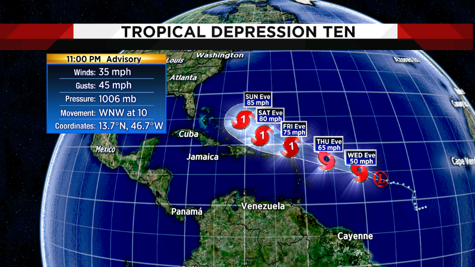
New depression in Atlantic expected to become tropical storm Wednesday
Read full article: New depression in Atlantic expected to become tropical storm WednesdayNOTE: Follow latest on this storm in new story:Tropical Story Jerry will become hurricane in CarribeanThe National Hurricane Center said Tropical Depression 10 formed Tuesday morning far out in the Atlantic. NHC also developed another depression in the Gulf of Mexico, that later became Tropical Storm Imelda Tuesday afternoon. Six hours later, the system was moving west-northwest at 10 mph with 35 mph winds. Soon to be Tropical Storm JerryIt is forecast to strengthen into a tropical storm -- likely to be called Jerry -- later Wednesday and become a hurricane by the time it moves near the northern Leeward Islands Friday. Elsewhere in the tropicsTropical Depression 11 formed in the Gulf offshore Freeport, Texas, about noon Tuesday and was upgraded hours later to Tropical Storm Imelda, with winds nears near 40 mph.

Hurricane Humberto gaining strength as it barrels toward Bermuda
Read full article: Hurricane Humberto gaining strength as it barrels toward BermudaWith wind speeds of 100 mph -- and gusts up to 120 mph -- the Category 2 storm could still become a major hurricane before it comes dangerously close Wednesday night to Bermuda. The hurricane will pass less than 100 miles north of the island territory, according to the current forecast track from the National Hurricane Center, which noted Tuesday at 11 a.m. A tropical storm warning and a hurricane watch have been issued by the Bermuda Weather Service. Only 21 hurricanes have passed within 100 miles of Bermuda over the past 100 years. The last hurricane to make landfall in Bermuda was Hurricane Gonzalo in 2014.

Cruise Erupts in Cheers as Late Passengers Jump On Board Just in the Nick of Time
Read full article: Cruise Erupts in Cheers as Late Passengers Jump On Board Just in the Nick of TimePeople onboard a cruise ship erupted in cheers as two fellow passengers raced back to the vessel before it left port in Bermuda's Ireland Island. The June 14 incident was captured on video by a passenger and posted on social media. Angela Rosetti was onboard the Norwegian Escape with her friend when the tardy passengers scrambled to the dock. The two made it on board the vessel just in the nick of time, and there was no tension among the other waiting passengers. It was really funny.RELATED STORIESCruise Ship Hit by Rogue 115 MPH Wind Gust, Injuring PassengersCosta Rican TV Host and New Husband Are Couple Left Behind as Cruise Sailed AwayCouple Frantically Races After Cruise Ship Leaving Without Them